June 21, 2016
Locative Media and the Production of Georesources – A Pan-Arctic Spatial Data Infrastructure
For much of the past century and counting the Arctic has been viewed as a difficult to access geographic region. In the Western imperial imagination, it has been an immense and difficult to measure locale to be gotten across by plane, hot air balloon, and icebreaker; claimed by means of exploration, scientific research, and extractive industries; and colonized through trade, industrial expansion, and ecological and human disease. Indigenous residents of the Arctic, from Inuvialut to Aleut and a host of indigenous minorities in the Russian Arctic, have millennial relationships with the water, ice, and land, or a complex combination of the three that make up the ‘ground’ of Arctic existences. In counterpoint to the above expeditionary incursions into inhabited land, indigenous practices in the Arctic have had to evolve in conjunction with this complex confluence of colonial and environmFor much of the past century and counting the Arctic has been viewed as a difficult to access geographic region. In the ental factors.
Over the past three decades, with the consolidation of the effects of global warming, it would seem like the Arctic has been slowly migrating from above the Arctic Circle of the world’s attention, and drifting into a problematic centre stage when it comes to making, documenting, and supporting evidentiary claims for the truth value inherent in the warming of our planet. With the effects of greenhouse gases amplified in the once ice-rich Arctic, its environmental, human, cryogenic, and territorial dimensions are becoming of increasing concern to a range of actors. Climate scientists, meteorologists, biologists, and others with an interest in the biotic pasts, presents, and futures of the Arctic are ever more concerned with monitoring the interacting and changing environmental, atmospheric, and hydrological states of the region. The United States’ National Science Foundation (NSF) Arctic Research Mapping Application gives a graphical accounting of this ramping up of scientific interest and activity. An animation documenting NSF funded research activities in the Arctic from 2004 to 2014, shows a gradual emergence of orange-dotted field research sites, looping red, orange, and yellow scientific cruises by the Polar Sea and Henry Larsen, and blue flags signaling the locations of its seven research hubs.1Cp. National Science Foundation, “Animation: NSF Arctic Research Activities 2004-2014”, Arctic Research Mapping Application, 2016. Available at: http://armap.org/map-gallery/ [accessed January 27, 2016].

Bearing in mind that this is merely a representation of the United States’ monitoring of diverse forms of Arctic research, and that the seven other countries that make up the Arctic Council, an intergovernmental body charged with managing Arctic-related issues, also have significant ongoing scientific sites and projects in the region, it becomes apparent that the scientifically inhabited Arctic is morphing into a zone of significant knowledge production.
Yet, while we are coming to know more about High Arctic hydrological cycles, extreme weather patterns, and the fluctuations in permafrost, the production of coordinated, reliable, and accessible geospatial information on the Arctic itself is still a work in progress. At present, the eight national mapping agencies of the individual states that make up the Arctic Council are attempting to consolidate their practices and datasets in order to produce a comprehensive Arctic Spatial Data Infrastructure (SDI). An SDI comprises an infrastructural assemblage of “policies, data, technologies, standards, delivery mechanisms, and financial and human resources”2Li et al., “Semantic-based web service discovery and chaining for building an Arctic spatial data infrastructure”, Computers & Geosciences, Vol. 37, 2011, p. 1753. that are charged with making spatial data available and accessible to enable informed decision-making and planning on the part of governments, corporations, indigenous groups, and scientists, amongst other users. While many nations undertake comprehensive measures to collect geospatial information on their territories, crossborder efforts in the Arctic have been slower to materialize. The national mapping agencies of Finland, Norway, Russia, and Sweden launched the GIT Barents project in the 1990s, an early effort at geodata cooperation that sought to increase geographical knowledge in the Barents region by enabling the production of a common geographic database shared via an Internet-based infrastructure following the principles set out by the European Union’s directives for spatial information infrastructures. The forms of cooperation that emerged largely concerned environmental planning and monitoring, natural resource development, and crossborder tourism in the Barents region. It was in October, 2011, that the Arctic Council officially launched its Arctic SDI initiative, with participants from all eight national mapping agencies. Their stated shared goal is to produce an Arctic SDI by 2020 in order to “provide politicians, governments, policy makers, scientists, private enterprises and citizens in the Arctic with access to geographically related Arctic data, digital maps and tools to facilitate monitoring and decision-making.”3Arctic SDI, “Arctic Spatial Data Infrastructure Framework Document”, Arctic SDI, Version 2.0, June 2015, p. 5. Available at: http://arctic-sdi.org/wp-content/uploads/2014/08/20150825-Arctic-SDI-Framework-Document_V2-0.pdf [accessed January 27, 2016]. While I will provide greater detail on the logics subsuming the creation of the Arctic SDI, as well as a foray into the technical components that will sustain its functioning, in a section below, the stakes that this intergovernmental geospatial knowledge production raises revolve around how the Arctic is not only being made available today as a data-driven location, but also the ways in which scientific infrastructures of research such as the Arctic SDI are, to some degree, rendering the Arctic exploitable as a collection of locative media. While this is simply the instrumental neutrality of ‘data’, it is also a case wherein an infrastructure, here of spatial documentation and visualization, can display a set of “values and ethical principles” that are “inscribe[d] in the inner depths of the built information environment.”4Susan Leigh Star, “The Ethnography of Infrastructure”, American Behavioral Scientist, Vol. 43, no. 3, 1999, p. 379. These values and ethical principles touch on how climate science and resource monitoring are parallel and partially mutually enabling infrastructures in the Arctic, and so by turning the Arctic into a diverse set of locative media datasets, the ambiguous function of the Arctic as both climate bellwether and resource panacea is maintained. Another way to put this is to ask if there is a case to be made for making locations, particularly in the Arctic, non-consumable as datasets. What other forms of evidentiary documentation can account for climate change in the Arctic?
In what follows, I draw on the foundational work of Susan Leigh Star, Karen Ruhleder, and Geoffrey Bowker. While a great deal of important scholarship on information infrastructures has emerged since their interest in the object of study peaked in the early to mid 1990s, their body of work continues to set the terms through which diverse infrastructural systems can be analyzed. Since they were looking at the early stages of the concretization of large-scale information producing, distributing, and tracking systems, it is these early glimpses into the architectural configurations of a data-driven system that we are still grappling with that retains their trenchant critical value. Since, as Star and Ruhleder contend, “infrastructure is something that emerges in practice, connected to activities and structures”5Susan Leigh Star and Karen Ruhleder, “Steps Toward an Ecology of Infrastructure: Design and Access for Large Information Spaces”, Information Systems Research, Vol. 7, no. 1, 1996, p. 112., it is precisely to the Arctic SDI as a case of infrastructural emergence that I would like to focus my attention. Now would seem to be the time to examine the Arctic SDI before it becomes a smoothly functioning spatial information infrastructure that is transparent to use, and generally displays all the qualities that Star and Ruhleder claim make up an infrastructure proper. At the time of writing in early 2016, the Arctic SDI comprises a host of what could be characterized as logistical media, reports, work flows, and early stage graphical user interfaces, that are all working towards becoming a fully functioning and shared pan-Arctic infrastructure by 2020. In a first section, “The Arctic as Spatial Data”, I examine this collection of logistical media and the ways in which it underpins the creation of an Arctic SDI that relies on locative media datasets. By ‘locative media’, I not only mean the production and “use of information, data, sounds, and images about a location”6Rowan Wilken and Gerard Goggin, “Locative Media – Definitions, Histories, Theories”, in Rowan Wilken and Gerard Goggin (eds.), Locative Media, London, Routledge, 2014, p. 2., but also the location-aware infrastructural, logistical, and geospatial processes that support the representing and delimiting of the Arctic region as consumable data. Here, as is often the case, the infrastructural and logistical both precede and enable the locative when it comes to documenting and consuming specific geographic locales. Subsequently, in “Interoperability and Standards of Space for Monitoring and Decision Making”, I examine the assumptions around interoperability and the standardization of space that the Arctic SDI would create. In “The Production of Un-‘Real Time’ Georesources”
I consider how the Arctic SDI is producing a largely graphical georesource that is blurring the line between scientific practices of knowledge creation and collection, resource management, and an infrastructure of and for locative media in a region that has only been marginally available to web mapping services, location-aware social media applications, and other forms of location-driven data extraction. Finally, a concluding section, “The Unrepresentable Arctic”, troubles the ways in which the Arctic SDI is an infrastructure that articulates the assumption that geospatial data constitute the epistemological ground informing ‘human’ decision making in the Arctic.
I – The Arctic as Spatial Data
Since its consolidation over the course of the second half of the twentieth century, the global geomatics market has been a relatively contained group of actors, largely government agencies and private corporations, that have sought to produce geospatial information of relevance and use to surveyors, civil engineers, extractive industries, and other users contending with the management of geographic resources and knowledge. The Canadian geomatics industry is an exemplary case as, given the country’s vast landmass and its reliance on multiple forms of resource extraction, it has been on the leading edge of geospatial information production since the early 1960s. A 2015 report published by Natural Resources Canada notes the transformative changes the geomatics industry has undergone since the early 2000s, with the advent of mobile computing, miniaturization, and the cost-reductions around geographic positioning systems. The report claims that these three factors combined “to transform a relatively specialized geomatics market into a more generalized ‘location’ market.”7Natural Resources Canada, “Canadian Geomatics Environmental Scan and Value Study”, Canadian Geospatial Data Infrastructure Information Product 41e, 2015: p.6. Available at:
http://geoscan.nrcan.gc.ca/starweb/geoscan/servlet.starweb?path=geoscan/fulle.web&search1=R=296426; accessed January 27, 2016. Along with this shift to location, came the emergence of “‘mass market geomatics’ players”8Ibid. such as Google Maps, MapQuest, and Microsoft Bing, which had the effect of widening the scope of location-aware users and their understanding of the value of location-based datasets.
It is into this geospatial information context that the Arctic SDI initiative is emerging. The active building and sustaining of location markets, enabled by the proliferation of GPS equipped handheld devices, is a concern for a range of corporations seeking to profit from their use of location analytics. What the group of nations behind the creation of an Arctic SDI is aiming to build is a geospatial information infrastructure that would be open, searchable, and usable by the broad range of actors noted above. As the Arctic SDI Framework document specifies, one of its expected benefits is the production of circumpolar-relevant “data that can be used for many purposes.”9“Arctic Spatial Data Infrastructure Framework Document”, p. 7. The confluence of these two sets of location-aware interests is both self-evident and complex: from corporations such as Google looking to enhance their locative potential in remote regions such as the Arctic, to conservationists seeking to better understand the environmental impacts of particularly harmful extractive industries. Data, in its plurality and seeming neutrality, always seems to serve those who can manage its modes of interpretation and control. While the Arctic SDI is striving to become a common tool to enable the exchange of accurate and up to date spatially referenced data, it is nonetheless dependent on the politicised and capital-intensive forms of action derived from its infrastructural operationalization of the Arctic. For instance, the 2015 Natural Resources Canada report cited above notes that the principal beneficiaries of ‘open’ geospatial data (available at little or no cost and subject to few or limited restrictions), measured by percentage change in industry output, are companies and agencies involved in mining, quarrying, and oil and gas extraction (4.54 per cent), transportation and warehousing (1.64 per cent), utilities (1.58 per cent), and public administration (1.51 per cent).10Cp. Natural Resources Canada, “Canadian Geomatics Study”, 2016. Available at: http://www.nrcan.gc.ca/earth-sciences/geomatics/canadas-spatial-data-infrastructure/cgdi-initiatives/canadian-geomatics [accessed January 27, 2016]. The social and environmental benefits surrounding habitat conservation, indigenous land rights, and the efficacy of public health campaigns provided by improved geospatial information were all deemed too difficult to measure. What is at stake here are the ways in which the Arctic is being rendered into a form of open geospatial data that can be mined by a broad spectrum of interests. “Like events imagined and enunciated against the continuity time”, as Lisa Gitelman and Virginia Jackson write, “data are imagined and enunciated against the seamlessness of phenomena.”11Lisa Gitelman and Virginia Jackson, “Introduction”, in Lisa Gitelman (ed.),“Raw Data” is an Oxymoron, Cambridge, Mass., MIT Press, 2013, p. 3. Thought of in terms of the practices of the extractive industries, what the Arctic SDI is enabling is a transformative process that is rendering the Arctic into a series of searchable themes and collections of metadata that can facilitate forms of governmental and corporate planning and control. While this is simply the working out of governmental logics, writ large, the world over, it is worthwhile to slow down and apprehend, following Star, the set of values and ethical principles that underpin the impetus to create an Arctic SDI and the ways in which it fits in with the broader turn in the geomatics industry, including locative media, and the creation of location markets. The Arctic SDI, in this optic, becomes perhaps indirectly an effort to move Arctic locations (and peoples) into the neutral eminent domain of data: a place of (open and proprietary) data exchange across which locative markets merge with the likes of climate science.
While national SDIs have been around for roughly four decades, striving to manage, document, and preserve geographic information of vital interest to individual nations, what is unique about the Arctic SDI initiative is its attempt to consolidate a pan-Arctic data flow that is endeavoring to lead from ‘collection to action’ across the Arctic as a circumpolar region.12Cp. “Arctic Spatial Data Infrastructure Framework Document”, p. 10. The United Nations is also currently attempting a similar effort surrounding Global Geospatial Information Management; see http://ggim.un.org/ [accessed January 27, 2016]. As this figure from the Arctic SDI Framework document depicts, it is an effort at centralising the geographic information relevant to the Arctic. Ultimately, “[t]he goal is to make it possible to access reference data through a cartographically homogenous Pan-Arctic background map distributed as a Web Map Service but also to give access to all kind [sic] of location based data (raster, vector and time-series) from the entire Arctic region.”13Ibid. This possible putting of the ‘Arctic‘ on a standardised (and now proverbial) Web Map Service might have as its ultimate effect of making the Arctic SDI into an infrastructure destined for the creation and maintenance of geographic information about the region as first and foremost an open-ended collection of logistical media. As John Durham Peters notes, this is a concept that “emphasizes the infrastructural role of media”, and it is one that articulates the ways in which knowledge about a region can be prioritised and made ‘actionable’.
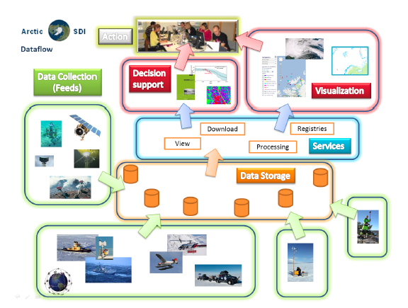
It also fundamentally gestures towards the central set of values and ethical principles that the Arctic SDI is building. These emphasise the logistical’s foregrounding of “storage, time and space”, as well as putting “processing front and center” in order to produce discrete datasets that can inform decision making and planning.14Cp. Jeremy Packer, “Becoming Mollusk: A Conversation with John Durham Peters about Media, Materiality, and Matters of History”, in Jeremy Packer and Stephen B. Crofts Wiley (eds.), Communication Matters: Materialist Approaches to Media, Mobility, and Networks, New York, Routledge, 2012, pp. 43-44. While my aim here is not to offer alternative, competing, or agonistic modes of geospatial information knowledge production, notably through the Arctic’s diverse indigenous ontologies of environmental inhabitation, it is rather to uncover the forms of access to and control over the Arctic’s various set of socio-political interests that the Arctic SDI, as an infrastructure in the making, might enable. Here, infrastructure building can obscure the valences of geospatial data – whom they serve, to what ends, and what they represent.
II – Interoperability and Standards of Space for Monitoring and Decision Making
It is important to emphasise that the Arctic SDI is indeed an infrastructure in the making. As a result, it is a critical opportunity to examine the ways in which the Arctic SDI is a result of, following Bowker, “infrastructural inversion.”15Cited in Star and Ruhleder, 1996, p. 113. Rather than seeing it exclusively as the outcome of such factors as Arctic Council policy, the desire for coordination across polar national mapping agencies, or a lack of detailed geographical knowledge of the Arctic region, the Arctic SDI also came about as new “infrastructural relations” emerged.16Cp. Ibid. In this sense, the Arctic SDI gained traction as a pan-Arctic infrastructural project precisely because it was a reflection of the emergent ways in which ‘locations’ are being consumed via digital practices of capture and representation, whether as locative media, web mapping services, or geospatial information datasets. Moreover, it is a spatial data infrastructure that has to be put into place in relation to existing SDIs. Thus, the interoperability of the Arctic SDI possesses a two-sided relational valence. The first, unacknowledged by the Arctic Council, is made manifest in its emergence out of the creation of location markets based on geospatial information datasets. The second is contained in the need for the Arctic SDI to be able to deliver data across a number of digital platforms. Where these two infrastructural relations meet is in the fundamental requirement that the Arctic SDI be built with the production and management of standardised spatial data at its foundation. It is the Arctic SDI’s infrastructure of standardisation that I will put under examination in this section because it reflects the ways in which it is an infrastructure that might be narrowing the ways in which we think about the Arctic as set of distinct intra-regional environments.
As I noted above, the central purpose of the Arctic SDI is to produce, manage, as well as make accessible spatial data relevant to the Arctic region. In order for the eight mapping agencies to establish a common data infrastructure, they all have to agree on the means by which they will standardise the data they seek to share. Here, ‘harmonisation’ of an infrastructure implies the creation of an infrastructure that can accommodate multiple sources of metadata, catalogues describing that metadata, various interfaces that enable searching and finding within those catalogues, and a set of tools to evaluate the georesources that it ultimately produces.17Cp. “Arctic Spatial Data Infrastructure Framework Document”, pp. 13-14. This operation of distillation of multiple spatial data infrastructures into a single, harmonised Arctic SDI, also displays how infrastructural relation possesses a formative agency that supersedes the forecasting of governments bodies – it shows how information infrastructures can build themselves in relation to past versions of themselves in the name of interoperability.
The two basic standards upon which the Arctic SDI is to be built are contained in the creation of a “common, basic digital background map” and a “common data model” into which each mapping agency can translate their own data outputs.18Cp. “Arctic Spatial Data Infrastructure Framework Document” Both of these, in part, rely on the protocols established by the Open Geospatial Consortium (OGC), “an international not for profit organization committed to making quality open standards for the global geospatial community.”19Open Geospatial Consortium, “Home”, 2016. Available at: http://www.opengeospatial.org/ [accessed January 27, 2016]. Much like the better-known International Organization for Standardization (ISO),20Cp. International Organization for Standardization, “Home”, 2016. Available at: http://www.iso.org/iso/home.html [accessed January 27, 2016]. the OGC’s mandate has the power to shape an infrastructure like the Arctic SDI in order to maximize the flow of spatial data equally across national boundaries as computer protocols. As is often the case, standardisation functions as an intra-infrastructure that serves to increase the base of users of an infrastructure, and, in the process, justify its centralising tendencies as an information source. For the Arctic SDI, the key moment of standardisation will occur around the implementation of a common web map service that adheres to the OGC’s standard, and will deliver “geo-referenced map images” to users.21“Arctic Spatial Data Infrastructure Framework Document”, p. 15; italics in original. While I will touch on the importance of these images in the section that follows, the insight to retain here is the degree to which this centralisation of spatial data might shape the ways in which the Arctic is approached as a distinct set of locations rather than a cohesive, supranational region made up of searchable georesources. As Adriana de Souza e Silva and Jordan Frith note:
„The popularization of location-aware mobile technologies not only highlights the importance of location, but also forces us to re-think how location has been traditionally conceptualized. Locations are still defined by fixed geographical coordinates, but they now acquire dynamic meaning as a consequence of the constantly changing location-based information that is attached to them.“22Cited in Wilken and Goggin, 2014, p. 3.
This process of ascribing meaning to changeable locations is not a simple matter of (geo) technical determinism. Rather, the making of the Arctic SDI highlights how worldly locations become information-bearing locations that can be actively produced, managed, and given access to by such a collective infrastructural project.
It follows that regions such as the Arctic can be made to cohere, politically and spatially, through these sorts of infrastructures in the making. As Star reminds us, who is not served by a given infrastructure is a question that is not only often obscured by large-scale information infrastructures, it is a question that is actively foreclosed by the incremental, ‘constructive’ relations that these infrastructures build in the name of interoperability through standardisation.23Cp. Star, 1999, p. 380. An infrastructure such as the Arctic SDI has, following de Souza e Silva and Eric Gordon, its own “constantly changing location-based information” built into its requirement of collective standardisation. For the Arctic in particular, as I touch on below, these involve the active production of searchable georesources that purport to represent a broad set of up to date spatial information. Yet, in Star’s estimation of infrastructural invisibility, it is the Arctic as an environment subject to decision making and planning that is not served while also paradoxically being that which is represented. This is not to contradict the ontological status of the ‘Arctic’ as it appears as an SDI. It is to assert that the forms of mediated decision making that the Arctic SDI endorses and encourages are predicated on forms of data capture and sharing that render the region into a collection of locative media that fail to take into account their own production of locations for an open-ended base of users and markets. Yet again, as I noted above, the infrastructural both precedes and produces the logistical. The standardising protocols shaping the ways in which the Arctic SDI will function resemble, as Ned Rossiter claims, the work undertaken by algorithms across logistics chains: “play[ing] a vital role in arranging the material properties and organizational capacities of infrastructure.”24Ned Rossiter, “Locative Media as Logistical Media: Situating Infrastructure and the Governance of Labor in Supply-Chain Capitalism”, in Rowan Wilken and Gerard Goggin (eds.), Locative Media, London, Routledge, 2014, p. 215.
III – The Production of Un-“Real Time” Georesources
What is essential to bring to the fore is that the common background map upon which the Arctic SDI will rely is really an articulation of the ways in which georesources can be made available as locative media. By this I mean that the various environmental phenomena, processes, and interpretable indicators that the Arctic will yield, are all subject to the claims of becoming a minable ‘georesource’ that contains information related to that specific location. As a result, within the terms of the Arctic SDI, distinct environments become localised instances of interpretable data; in other words, sea ice can become a locative medium. While such SDI’s project the values of accuracy and up-to-dateness as part of their infrastructural coherence, in fact, the proliferation of real time geographic spatial imagery is a process that the GIS community has had a difficult time containing. As the OGC’s OpenGIS Abstract Specification “Topic 7: The Earth Image Case” notes, there is a growing tension between the volume of geographic imagery being produced (with national mapping agency archives increasing by a terabyte a day, and tens of thousands of catalogued spatial datasets not yet available on-line) and the limited attention of those human users and decision makers.25Cp. Open Geospatial Consortium, The OpenGIS Abstract Specification, “Topic 7: The Earth Imagery Case”, Version 5, 2004, xi. Available at: https://portal.opengeospatial.org/files/?artifact_id=7467 [accessed January 27, 2016]. Thus the interactions between the infrastructural systems that are producing geographic imagery and the purported human beneficiaries will be subject, according to the OGC, to “semantic processing”26Ibid., such as the automatic detection of geographic features by pre-programmed algorithms, or the mining of information based on pre-determined geographic concepts – both forms of automated processing that could decrease the accuracy and reliability of the spatial data informing these human decisions. What I want to signal in this section are the unreliable forms of imagery that such an information-bearing infrastructure as the Arctic SDI will rely on. As Star reminds us, “[i]n information infrastructure[s], every conceivable form of variation in practice, culture, and norm is inscribed at the deepest levels of design”27Star, 1999, p. 389., and in this instance the production of location-bearing images is the result of a compromise between spectral reproductions and colour-based representations of the natural world. While this might seem like delving into much too deep a level of infrastructural design, it is significant as it indicates the ways in which standardised geographic imagery is actively produced by multiple location-bearing media, from remote sensors to computer-generated reproductions, each with distinct capacities of accuracy and reliability.
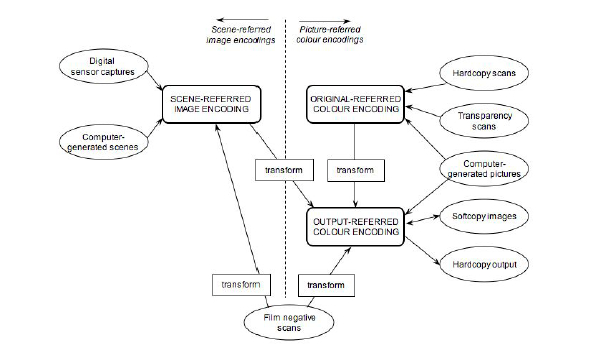
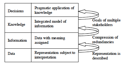
This diagram from the OGC’s “Topic 7” displays the basic bifurcation at the heart of geographic imagery. Scene-referred image encodings and picture-referred colour encodings are two distinct image states. They are combined in order to produce and ultimately represent a wealth of spatial data. As the basic unit, a single geographic image, of a geographic information system, it constitutes the central interface through which sensor data is made manifest: “Scene-referred encodings are representations of an original scene, where a scene is defined to be the spectral radiances of a view of the natural world as measured from a specified vantage point in space and at a specified time.”28Open Geospatial Consortium, “Topic 7: The Earth Imagery Case”, p. 8. With this data being tempered by processes of colour capture and representation that rely on “the colour-space coordinates (or an approximation thereof) of a two-dimensional hardcopy or softcopy input image,” including, for example, “printed maps, printed pictures of a geographic scene, [or] drawings of geographic information.”29Ibid., p. 9. This active production of a geographic image is taken up into what the OGC calls the “information viewpoint.” This is a technical specification that “identifies the various types of geographic information and shows the relationships of raw sensed data to higher semantic content information and knowledge.”30Ibid., p. 13. The information viewpoint adopts a semiotics-derived structure wherein, as this diagram indicates, data form the base level of representation subject to initial interpretation. As a result, the geographic image I described above is really the foundation upon which the “[p]ragmatic application of knowledge” relies. On the whole, the Arctic SDI, in its forms of institutional and technical organisation, is essentially congruent with the OGC’s information viewpoint.
What this somewhat passive, technical language of the OGC’s abstract specification conceals are the consequences of relying on a geographic image as a scene-referred encoding. Error and variability in accuracy are, of course, ever present in all remote sensing devices and practices. Whether across forms of resolution that are radiometric (referring to energy intensity levels) or spectral (varying across bands in the electromagnetic spectrum), and in the processes of data acquisition and conversion, the potential for the distance between the phenomena of the scene being captured and its subsequent rendering into actionable and discrete datum leaves us with a very uncertain and unreliable approximation of ‘location’ indeed. If, as I claimed above, the Arctic SDI is reliant on the production of an image-based georesource bearing location-information, then it could follow that the very Arctic locations to be mapped are at several more significant equally semantic as digitally-descriptive removes from the ‘real time’ of the SDI’s data-driven promise.
This collection of technical specifications and the broader potential of standardising practices, when brought together to support a project such as the Arctic SDI, point to the need to examine the infrastructural protocols that infrastructures-in-the-making project and design for forms of future use. With a standardised Web Map Service serving as the basis of the Arctic SDI’s pan-national information sharing program, uncovering its digital building blocks and processes of protocol decision making can allow us to question how an infrastructure is being built, and possibly influence its design well before it becomes, in Star and Ruhleder’s terms, transparent to use.
IV – The Unrepresentable Arctic
While it would seem like the Arctic SDI is indeed an open-ended promise in the production of geospatial data of relevance to the Arctic, the equally open-ended question remains as to what precise ‘Arctic’ it will ultimately document, interpret, and map. With the infrastructure’s emphasis on pan-national sharing of spatial data via standardising practices, it is to comparative and multinational Arctic concerns that it is most squarely addressed. As such, one of the underlying aims of this particular SDI, as it is with the Arctic Council in general terms, is to enable forms of national cooperation and consensus on territorial claims in the Arctic region; a particularly contentious issue with regards to the Arctic Ocean’s seafloor and the potential oil and gas deposits that it might yield to the countries claiming ownership over overlapping sections of it. In this geopolitical context, the production of reliable and timely georesources can only serve to obscure the more grounded concerns of Arctic residents, both indigenous and non-indigenous, grappling with the effects of climate change in the more pragmatically and urgently defined ecology that is the Arctic today. The Arctic SDI, like many critical information infrastructures, will ultimately not be a mere enabling tool readily available for use by a wide range of actors. “Many information systems”, as Star writes, “employ what literary theorists would call a master voice, or a single voice that does not problematize the diversity. This voice speaks unconsciously from the presumed center of things.”31Star, 1999, p. 384. While the Arctic SDI purports to function as a mere conduit of geospatial data, it is nonetheless an infrastructure that articulates the assumption that geospatial data constitute the epistemological ground informing ‘human’ decision making in the Arctic. Furthermore, it tacitly endorses a hierarchical bounding of spatial knowledges that renders complex, ecologically- and humanly-sited Arctic locations into locative media in the service of georesource data production. This is not to lay claim to other, perhaps more just foundational narratives such as that surrounding certain understandings of traditional ecological knowledge, a social formation that sees the necessity of foregrounding the primacy of generational indigenous experiences interacting with and sustaining their surrounding ecosystems.32Cp., by way of example, Fikret Berkes, Sacred Ecology: Traditional Ecological Knowledge and Resource Management, Philadelphia, Taylor and Francis, 1999 and Paul Nadasday, “The Politics of TEK: Power and the ‘Integration’ of Knowledge”, Arctic Anthropology, Vol. 36, nos. 1 and 2, 1999: pp. 1-18. Nor is it to elide the valuable and rigorous forms of scientific data collection, meteorological and other, that such sensor-driven spatial knowledges are allowing us to come to know. It is rather to emphasise the ways in which locations across the Arctic are being mediated into data – rendered logistical in the pursuit of locative, operational knowledge; with this process taking precedent and asserting its protocols of accuracy and legitimacy over the ‘decisions’ to be taken in the Arctic region in these early decades of the twenty-first century. Following Peters, now is the time for the emergence of a form “infrastructuralism” that has as its primary goal “to make environments visible.”33John Durham Peters, The Marvelous Clouds, Chicago, University of Chicago Press, 2015, p. 38. Taking apart the potentialities of the Arctic SDI is a crucial first step in making marginal, environmentally derived ontologies central to the design and functioning of large-scale information sharing systems.
The unrepresentable Arctic is thus not a territory outside the bounds of the capitalist-extractive nexus that has partly characterised recent efforts to intensify southern claims to the Arctic region. It is rather the set of relationships that such critical information infrastructures could be making in relation to existing ‘organised practices’ and knowledges across Arctic locales. What would be of real value for this currently unrepresented, and, in part, unrepresentable dimension of Arctic ontologies, is an infrastructure that works into its design, from the protocol level up, what could be thought of as forms of Arctic knowledge that articulate indigenous environmental practices of inhabited use when it comes to producing georesources. The question that remains is not really “what might this resemble?” Rather, at present we should turn to the set of relationships that the Arctic SDI needs to build in order to be a responsive information infrastructure that might one day be transparent to use for Arctic residents across national boundaries.
| ↑1 | Cp. National Science Foundation, “Animation: NSF Arctic Research Activities 2004-2014”, Arctic Research Mapping Application, 2016. Available at: http://armap.org/map-gallery/ [accessed January 27, 2016]. |
|---|---|
| ↑2 | Li et al., “Semantic-based web service discovery and chaining for building an Arctic spatial data infrastructure”, Computers & Geosciences, Vol. 37, 2011, p. 1753. |
| ↑3 | Arctic SDI, “Arctic Spatial Data Infrastructure Framework Document”, Arctic SDI, Version 2.0, June 2015, p. 5. Available at: http://arctic-sdi.org/wp-content/uploads/2014/08/20150825-Arctic-SDI-Framework-Document_V2-0.pdf [accessed January 27, 2016]. |
| ↑4 | Susan Leigh Star, “The Ethnography of Infrastructure”, American Behavioral Scientist, Vol. 43, no. 3, 1999, p. 379. |
| ↑5 | Susan Leigh Star and Karen Ruhleder, “Steps Toward an Ecology of Infrastructure: Design and Access for Large Information Spaces”, Information Systems Research, Vol. 7, no. 1, 1996, p. 112. |
| ↑6 | Rowan Wilken and Gerard Goggin, “Locative Media – Definitions, Histories, Theories”, in Rowan Wilken and Gerard Goggin (eds.), Locative Media, London, Routledge, 2014, p. 2. |
| ↑7 | Natural Resources Canada, “Canadian Geomatics Environmental Scan and Value Study”, Canadian Geospatial Data Infrastructure Information Product 41e, 2015: p.6. Available at: http://geoscan.nrcan.gc.ca/starweb/geoscan/servlet.starweb?path=geoscan/fulle.web&search1=R=296426; accessed January 27, 2016. |
| ↑8 | Ibid. |
| ↑9 | “Arctic Spatial Data Infrastructure Framework Document”, p. 7. |
| ↑10 | Cp. Natural Resources Canada, “Canadian Geomatics Study”, 2016. Available at: http://www.nrcan.gc.ca/earth-sciences/geomatics/canadas-spatial-data-infrastructure/cgdi-initiatives/canadian-geomatics [accessed January 27, 2016]. |
| ↑11 | Lisa Gitelman and Virginia Jackson, “Introduction”, in Lisa Gitelman (ed.),“Raw Data” is an Oxymoron, Cambridge, Mass., MIT Press, 2013, p. 3. |
| ↑12 | Cp. “Arctic Spatial Data Infrastructure Framework Document”, p. 10. The United Nations is also currently attempting a similar effort surrounding Global Geospatial Information Management; see http://ggim.un.org/ [accessed January 27, 2016]. |
| ↑13 | Ibid. |
| ↑14 | Cp. Jeremy Packer, “Becoming Mollusk: A Conversation with John Durham Peters about Media, Materiality, and Matters of History”, in Jeremy Packer and Stephen B. Crofts Wiley (eds.), Communication Matters: Materialist Approaches to Media, Mobility, and Networks, New York, Routledge, 2012, pp. 43-44. |
| ↑15 | Cited in Star and Ruhleder, 1996, p. 113. |
| ↑16 | Cp. Ibid. |
| ↑17 | Cp. “Arctic Spatial Data Infrastructure Framework Document”, pp. 13-14. |
| ↑18 | Cp. “Arctic Spatial Data Infrastructure Framework Document” |
| ↑19 | Open Geospatial Consortium, “Home”, 2016. Available at: http://www.opengeospatial.org/ [accessed January 27, 2016]. |
| ↑20 | Cp. International Organization for Standardization, “Home”, 2016. Available at: http://www.iso.org/iso/home.html [accessed January 27, 2016]. |
| ↑21 | “Arctic Spatial Data Infrastructure Framework Document”, p. 15; italics in original. |
| ↑22 | Cited in Wilken and Goggin, 2014, p. 3. |
| ↑23 | Cp. Star, 1999, p. 380. |
| ↑24 | Ned Rossiter, “Locative Media as Logistical Media: Situating Infrastructure and the Governance of Labor in Supply-Chain Capitalism”, in Rowan Wilken and Gerard Goggin (eds.), Locative Media, London, Routledge, 2014, p. 215. |
| ↑25 | Cp. Open Geospatial Consortium, The OpenGIS Abstract Specification, “Topic 7: The Earth Imagery Case”, Version 5, 2004, xi. Available at: https://portal.opengeospatial.org/files/?artifact_id=7467 [accessed January 27, 2016]. |
| ↑26 | Ibid. |
| ↑27 | Star, 1999, p. 389. |
| ↑28 | Open Geospatial Consortium, “Topic 7: The Earth Imagery Case”, p. 8. |
| ↑29 | Ibid., p. 9. |
| ↑30 | Ibid., p. 13. |
| ↑31 | Star, 1999, p. 384. |
| ↑32 | Cp., by way of example, Fikret Berkes, Sacred Ecology: Traditional Ecological Knowledge and Resource Management, Philadelphia, Taylor and Francis, 1999 and Paul Nadasday, “The Politics of TEK: Power and the ‘Integration’ of Knowledge”, Arctic Anthropology, Vol. 36, nos. 1 and 2, 1999: pp. 1-18. |
| ↑33 | John Durham Peters, The Marvelous Clouds, Chicago, University of Chicago Press, 2015, p. 38. |

Rafico Ruiz is the Roberta Bondar Postdoctoral Fellow in Northern and Polar Studies at Trent University, as well as an FQRSC Postdoctoral Fellow. He holds a Ph.D. in Communication Studies and the History & Theory of Architecture from McGill University. He studies the relationships between mediation and social space, particularly in the Arctic and Subarctic; the cultural geographies of natural resource engagements; and the philosophical and political stakes of infrastructural and ecological systems. His work appears in the International Journal of Communication, Continuum: Journal of Media & Cultural Studies, and Communication +1, amongst others. In Spring of 2015, he was a visiting fellow at Leuphana University’s Centre for Digital Cultures.